Friday, September 27, 2013
Dayl 11: Naples, FL : 329.5 miles; 4:50
We made it to Naples and LensCrafters. Will be out of communication for a few days. No wireless here. Will be back on tHe road Tuesday.
Thursday, September 26, 2013
Day 10: Lake City, Florida: 341.2 miles; 5:48
Jim's glasses fell apart as we were getting packed up, so he borrowed some super glue from the office and got them back together--sort of. We took off at 7:53 and headed south on I-55 towards Montgomery.
First town we passed was Wetumpka (6,528; 191 ft.). Wetumpka is known as the "City of Natural Beauty." The Coosa River flows through the middle of the town. Upriver you can see sn unusual rock formation rising out of the water. This is the remains of a 4-mile wide crater formed 83 million years ago as a meteor more than 1,100 feet wide crashed into the earth's surface. Today's city sits right on the bull's-eye. (Logic similar to , "Lightning doesn't strike the same spot twice??")
We got off the Interstate at Montgomery and ended up on a 4-lane road called the "Troy Highway." This was like a freeway only with regular intersections. You could go fast in the country, but when you got to a town, there were a number of stop lights. We figured that you could measure the size of a town by the number of stop lights -- just like we measure the size on the Interstate by the number of exits.
At Troy, we saw a sign, "Have More Fun in Troy -- Zip Lines." Wasn't expecting that. Troy University is somewhere around here and according to the signs, we were in "Trojan Territory." It is also "piggly wiggly," "Chick-fil-a," "Whataburger," and peanut and pecan territory. We saw our first cotton fields and passed the "Nut-Bama Hut" offering pecan everything.
We stopped at the only rest stop on the highway. There was a sign as you entered the building that said, "No weapons inside." Someone had blacked out the "No."
We saw a turn-off for a "historic marker." There was a boat at the entrance positioned at a rather odd angle, almost vertical. I figured this was either an odd form of art similar to the windmill art in Iowa, or the boat had some significance. So we decided to make up our own story ... Jim's story was that the boat was blown here by Hurricane Katrina.
Just before Dotham ( 65,000, 355 ft.), Jim's glasses fell apart again. Fortunately we were at a stoplight by a shopping area so we stopped. We went to Lowe's to get some glue, then Jim worked on his glasses and I went to Bed Bath and Beyond to get him a better butt-pillow. When I got back, his glasses were together, but there was a large glue smudge on the lens thanks to a Parkinson tremor. So we stopped at Target and I got some nail polish remover, alcohol, and q-tips to try and get rid of the smudge. Those didn't work, but strangely enough when Jim decided to try some of my Dr. Pepper it worked better...Makes you wonder.
We got back on the road and entered the Dotham "circle" which is a cross between a beltway and a traffic circle. You circle around town and take off on one of the spokes heading in different directions. We turned on the south fork to connect with I-10 in Florida.
Soon we entered the "Sunshine State." We saw the Florida Welcome Center and rest stop, followed immediately by the Lotto Discount Liquor Store, which told me that there must be some cross-border traffic. We saw signs for "gater jerky" and "boiled peanuts", and at Marianna, we saw our first palm trees.
Soon we were on the Interstate again. First town of note was Tallahassee (181,000, 216 ft.). It was the only Confederate Capitol east of the Mississippi not captured by union troops. The area is full of rolling hills, oak forests, rivers, beautiful landscapes, and large lakes. I don't quite know the difference between a "lake" and a swamp around here. Lot's of water by whatever name. The Interstate is elevated through this area.
We passed over the Suwannee River and stopped at the next rest stop. We noticed a large sign stating that the area was "Patrolled by armed guards at night." After that we noticed that the rest stop signs would advertise that they had "Nighttime Security." So rest stops in Florida are "modern" and "secure."
We turned south onto I-75 and pulled off at the next exit to spend the night in Lake City (population 12,000). Lake City was originally a Seminole Village. There is a Battlefield near here that was the place where the Confederate soldiers turned back the union troops marching towards Tallahassee. They hold a reenactment of this battle in February.
We pulled into a Best Western which had a "lake" water feature in front. Jim jokingly asked the clerk if there were alligators in the swimming pool. She said, "Oh, that happened before I came to work here." Evidently, about two years ago an alligator meandered into their water feature, then migrated to the swimming pool." He was relocated.
I went out to take pictures of the alligator's path. I found a gap in the fence. The water feature looks like a gater's delight and then on to the pool.


We went into Lake City to see the "lake." The name is "Lake" city, so there must be a lake, right? The only lake I could find on the map was called "Alligator Lake" and located south of town. We found the lake, but there was no park or scenic pull-out. So we went back to the "historic" downtown area.
They have a very nice town square and park. Behind the courthouse, I glimpsed water. We found our way back there and there was a "lake" (Jim called it a reservoir) behind the town center with a one-way driving/walking path around it. It was rather small, less than a quarter mile in diameter. "Lakes" seem to be very common in this area.
We had dinner and called it a day. Should make it to Naples tomorrow! Our first stop will be LensCrafters.
Wednesday, September 25, 2013
Day 9: Clanton, Alabama; 461.4 miles; 7:18; Total Miles breaks 3,000.
This was a travel day. As we started out and it was very muggy with misty clouds close to the ground. At Hayti, Mo. we were joined by a drove of trucks. As we entered Arkansas we saw a sign saying "Speed Limit Strictly Enforced, No Tolerance." Welcome to Arkansas.
Our short trip through Arkansas was full of road construction. The only site of interest was a small yellow airplane buzzing the highway. Jim thought it must be a crop duster. We were in the flatlands again, low elevation.
We stayed on I-55 to Memphis, although I had to trick Miss Direction who wanted us to go off onto side roads to Birmingham. Sometimes you have to finesse her to get her to take the route you want. We crossed the Mighty Mississippi River into Tennessee and Memphis (population 646,889; elevation 387 ft).
We were on the beltway and all was going well until we exited onto US 78 towards Birmingham. This dumped us onto a 4-lane, city road and a wall of trucks. At one point we had about 10 trucks in front of us and 10 behind -- makes you feel awfully small. As we got out of Memphis, the traffic opened up with all the trucks in the right lane and a wide-open left lane in front of us. Jim was tempted to floor it, but common sense prevailed and he set the cruise control for 70 mph. He did determine that they probably do not "strictly" enforce the speed limit in this state because everyone was passing us (including the trucks.)
As we left Memphis, we entered Mississippi. First town of note was Holly Springs (population 7,699; elevation 601 ft). The town was established during the great antebellum cotton boom. General Ulysses S. Grant set up a supply depot here in 1862 then departed for Vicksburg. By the end of the war, the town had been raided by the union soldiers 62 times.
In mid-September the town celebrates the migration of the ruby-throated hummingbird. Thousands of birds gather here at Strawberry Plain Audubon Center on their way from Canada to Central America.
At this point US 78 had turned into a 4-lane freeway similar to the Avenue of the Saints we traveled yesterday. Since it goes through Tupelo (population: 34,546; elevation 270 ft.) which is the birthplace of Elvis Presley, I thought they should name this Avenue of the King. As for rest areas, there were none by any name, so we decided to stop in Tupelo for a rest stop. Jim made it clear that although he liked Elvis's music, he was NOT stoping for any touristy Elvis places.
We got off following the sign for Tupelo and ended up on another 4-lane freeway. We took the next exit and were completely turned around. We stopped at a connivence store where Jim's first question to the clerk was, "How in the world do you get back on the highway to Birmingham?" She said that she gets that question all the time and described a rather convoluted route back. She said that although you could see the freeway we wanted from the store, you had to go in the opposite direction to get there. We made it back with some help from Miss Direction.
Jim wanted me to make sure and give this travel warning: DO NOT GET OFF THE FREEWAY AT TUPELO FOR ANY REASON. It is sort of like getting stuck on Sandy Blvd. in Portland. You can not be sure you can ever get back.
Not too far from Tupelo we crossed over a bridge over the Tallahatchie River.
We entered Alabama and were greeted with signs that say: "Lights on When Raining." Makes us wonder about the rain here. So far we haven't seen any today. This area is pretty country with rolling hills and lots of trees, both deciduous and evergreen. This area is at the tail-end of the Appalachian Mts. The trees are still short by Northwest standards, but taller than in the midwest. And we noticed that the Billboards were very high up. So high, they are hard to read. After a while, we realized they were high so they would be above the trees.
We made it through Birmingham (population: 212,237; elevation: 1,200 ft.) with the help of Miss Direction. Reminded me of Seattle traffic. We couldn't take the beltway, so drove right through the city. As we approached the city we saw what Jim calls the "Smokestacks of Birmingham." Birmingham was once called the "Pittsburg of the South" because of the numerous ironworks in the area. This is also the place where Martin Luther King was arrested and wrote his famous "Letter form a Birmingham Jail."
We decided to get as far from the big cities as we could to find a place to stay. We chose Clanton (population 8,619; elevation 600 ft.) which is about half-way from Birmingham to Montgomery.
We traveled many miles today. Looks like we will get to Florida tomorrow, but Florida is a VERY long state. Hope to be in Naples Friday or Saturday.
Tuesday, September 24, 2013
Day 8: Cape Girardeau, Missouri ; 425 miles; 6:45
We got up and were on the road by 9:00 after dropping by Casey's to see where Linda goes off to so early in the morning. We started out going east on Highway 34 following the first part of Rob's truck route.
First town we came to was Ottumwa (population 25,000; elevation 649). The town was named for the Native American word meaning "rippling waters." The city is on both sides of the Des Moines River. They also have an attraction called "Beach Ottumwa" which is a water park with wave pool, a 340 ft body slide and even a sand volley ball court.
We took a 6 mile side trip to Eldon to see the "Gothic House." This was the house shown in the painting by Grant Woods called American Gothic. They had an information center where "costumes are available for personal photography." Jim said, "No way!" So I just got a picture of the house.


At Mount Pleasant we turned south onto the "Avenue of the Saints," a recently finished 4-lane highway that connects Saint Paul with Saint Louis. An hour or so later, we were in Missouri. We soon saw signs for a "roadside park." It had picnic tables and trees, but no restrooms. Jim figured it was not "modern."
We had to slow down for several farm equipment vehicles on the road. Earlier, we had mentioned farm vehicles to Rob when we were talking about "wide loads" and he said, "Oh, farm vehicles have their own rules." So we figured that mining vehicles have their own rules in Wyoming, and farm vehicles have their own rules in the midwest.
The freeway curved to the east and we went through a stretch of stop lights right through the city of Hannibal, Missouri. Hannibal is the place where Mark Twain grew up, and he based his Tom Sawyer books on this area. There was a scenic route along the river with points of interest related to Tom Sawyer. We decided to forgo the side trip to prevent arriving in Saint Louis during rush hour. We did pull into the Visitor Information Center, hoping that it was "modern." Fortunately, it was. Also picked up a map and some information about Cape Girardeau, where we decided to stop for the night (about 100 miles south of Saint Louis.)
Missouri has some unique roadside quirks. First of all they put mileage markers out every two-tenths of a mile (instead of every mile). Second, state roads are not numbered; they are lettered. That is, we have state Route "E" and Highway "KK." Thirdly, they name their cities after other states and countries. It was confusing to see a road sign directing us to "Mexico" and "Louisiana" (this was on the same sign. I also noticed that there is a "Florida" Missouri. And finally, they have signs warning of "photo-enforced red lights." Thanks again, Gary :-)
We got to Saint Louis ( population 348,187; elevation 585 ft.) about 2:00 and ended up on a beltway (I-270). There was a lot of traffic and five to six lanes in each direction. Jim started complaining about all the downtown traffic. I told him, "We are on the by-pass." Really glad we weren't there at rush hour.
We headed south on I-55 towards Memphis and stopped in Cape Girardeau which was established as a trading post in 1733 on the banks of the Mississippi River and settled by Spanish immigrants who were offered inexpensive, tax-exempt land.
We stopped at exit 96 and found a promising motel -- there were quite a number of motels here for a town with a population of 38K. When I tried to check in, they only had one room left, a smoking room on the third floor. We decided to try the next exit since this exit was very congested. We found a nice hotel; no rooms. This is Tuesday. What gives?
I asked the clerk why all the rooms in town were full. He said that Ben Affleck was making a movie in town. It's a film called "Gone Girl." He said a lot of the crew and actors were staying in town. Also, there were several events going on at the college, including parent's weekend coming up.
The clerk called some other hotels for us and found one hotel that had 3 rooms left, so we hurried off to check in. It turned out to be a really nice hotel. It's right next to the freeway, but it is a little tricky to get to, so maybe that's why they had a few rooms left. I did hear the clerk tell someone on the phone that they were full on Saturday and only had a few rooms left on Friday. The hotel has a large indoor recreation center where they serve breakfast. The inner courtyard also has a pool downstairs and pool tables and ping pong upstairs. You would never know from looking on the outside that it has all these features on the inside.
We took a ride downtown. Once you get past all the hotels and strip malls, the town is old and charming. Lots of beautiful brick buildings and the main street parallels the river. There is a large sea wall along the river with murals painted on the cement slabs. There is also a casino in town which we didn't find, but we did find the college. It is down by the river overlooking a very picturesque bridge.

The college is Southeastern Missouri State University with an enrollment of 11,729. Their mascot is "Rowdy the Redhawk."

Heading back, we found "The Pasta House" and had a delicious pasta dinner. The waitress told us that the movie crew had come on campus auditioning students to be in the movie.
We went back to the motel and played a little ping pong. Then Jim went down for "Cookies and Milk" which they have every night from 8:00 - 9:00.
I had time to catch up on the last episode of "Breaking Bad" before turning over the Kindle to Jim who is now watching the Denver/Oakland game.
We checked the weather channel and it looks like the bad weather may clear out before we get there. We'll see tomorrow as we head for Mississippi and Alabama.
First town we came to was Ottumwa (population 25,000; elevation 649). The town was named for the Native American word meaning "rippling waters." The city is on both sides of the Des Moines River. They also have an attraction called "Beach Ottumwa" which is a water park with wave pool, a 340 ft body slide and even a sand volley ball court.
We took a 6 mile side trip to Eldon to see the "Gothic House." This was the house shown in the painting by Grant Woods called American Gothic. They had an information center where "costumes are available for personal photography." Jim said, "No way!" So I just got a picture of the house.


At Mount Pleasant we turned south onto the "Avenue of the Saints," a recently finished 4-lane highway that connects Saint Paul with Saint Louis. An hour or so later, we were in Missouri. We soon saw signs for a "roadside park." It had picnic tables and trees, but no restrooms. Jim figured it was not "modern."
We had to slow down for several farm equipment vehicles on the road. Earlier, we had mentioned farm vehicles to Rob when we were talking about "wide loads" and he said, "Oh, farm vehicles have their own rules." So we figured that mining vehicles have their own rules in Wyoming, and farm vehicles have their own rules in the midwest.
The freeway curved to the east and we went through a stretch of stop lights right through the city of Hannibal, Missouri. Hannibal is the place where Mark Twain grew up, and he based his Tom Sawyer books on this area. There was a scenic route along the river with points of interest related to Tom Sawyer. We decided to forgo the side trip to prevent arriving in Saint Louis during rush hour. We did pull into the Visitor Information Center, hoping that it was "modern." Fortunately, it was. Also picked up a map and some information about Cape Girardeau, where we decided to stop for the night (about 100 miles south of Saint Louis.)
Missouri has some unique roadside quirks. First of all they put mileage markers out every two-tenths of a mile (instead of every mile). Second, state roads are not numbered; they are lettered. That is, we have state Route "E" and Highway "KK." Thirdly, they name their cities after other states and countries. It was confusing to see a road sign directing us to "Mexico" and "Louisiana" (this was on the same sign. I also noticed that there is a "Florida" Missouri. And finally, they have signs warning of "photo-enforced red lights." Thanks again, Gary :-)
We got to Saint Louis ( population 348,187; elevation 585 ft.) about 2:00 and ended up on a beltway (I-270). There was a lot of traffic and five to six lanes in each direction. Jim started complaining about all the downtown traffic. I told him, "We are on the by-pass." Really glad we weren't there at rush hour.
We headed south on I-55 towards Memphis and stopped in Cape Girardeau which was established as a trading post in 1733 on the banks of the Mississippi River and settled by Spanish immigrants who were offered inexpensive, tax-exempt land.
We stopped at exit 96 and found a promising motel -- there were quite a number of motels here for a town with a population of 38K. When I tried to check in, they only had one room left, a smoking room on the third floor. We decided to try the next exit since this exit was very congested. We found a nice hotel; no rooms. This is Tuesday. What gives?
I asked the clerk why all the rooms in town were full. He said that Ben Affleck was making a movie in town. It's a film called "Gone Girl." He said a lot of the crew and actors were staying in town. Also, there were several events going on at the college, including parent's weekend coming up.
The clerk called some other hotels for us and found one hotel that had 3 rooms left, so we hurried off to check in. It turned out to be a really nice hotel. It's right next to the freeway, but it is a little tricky to get to, so maybe that's why they had a few rooms left. I did hear the clerk tell someone on the phone that they were full on Saturday and only had a few rooms left on Friday. The hotel has a large indoor recreation center where they serve breakfast. The inner courtyard also has a pool downstairs and pool tables and ping pong upstairs. You would never know from looking on the outside that it has all these features on the inside.
We took a ride downtown. Once you get past all the hotels and strip malls, the town is old and charming. Lots of beautiful brick buildings and the main street parallels the river. There is a large sea wall along the river with murals painted on the cement slabs. There is also a casino in town which we didn't find, but we did find the college. It is down by the river overlooking a very picturesque bridge.

The college is Southeastern Missouri State University with an enrollment of 11,729. Their mascot is "Rowdy the Redhawk."

We went back to the motel and played a little ping pong. Then Jim went down for "Cookies and Milk" which they have every night from 8:00 - 9:00.
I had time to catch up on the last episode of "Breaking Bad" before turning over the Kindle to Jim who is now watching the Denver/Oakland game.
We checked the weather channel and it looks like the bad weather may clear out before we get there. We'll see tomorrow as we head for Mississippi and Alabama.
Monday, September 23, 2013
Day 7: Chariton, Iowa
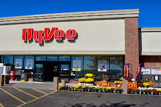
Spent the day in Chariton, birthplace of HyVee. HyVee is a popular grocery store chain in the midwest. When they originally started, they only opened stores in small towns (5,000 or less) and one of their first stores was in Chariton. They originally had their main headquarters here as well. As new owners took over, the company expanded into larger towns and moved headquarters to Des Moines. They still have a major warehouse in Chariton and have built a new larger store just off highway 34.


We went for a walk downtown in the morning. This is a wonderful small town. Jim noticed that there were three things missing: no Walmart, no Starbucks, and no McDonalds. He also noticed that the sidewalks in Chariton are NOT Parkinson's friendly. In fact they are downright unfriendly -- uneven and in disrepair.

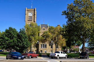
The town square is centered around a wonderful old county courthouse. We went inside. There was a small sign on the large wooden door that said "no firearms." That's all. No airport-style security system like they have installed in the Clark County Courthouse at home. Last time I went to the Clark County Courthouse, they confiscated a small pair of scissors I had in my purse. Then I found out the accessor's office I was looking for had moved to a new office building next door...
The door creaked (Jim thought they could use some WD-40), and some of the floor tiles were broken, but the inside was charming with old wood moldings and panelling. And the accessor's office was right there on the first floor. Back outside, we sat on one of the many park benches in front and enjoyed the great weather, 70's and sunny. Then strolled around the building reading signs telling of experiences of early settlers on the "Mormon Trail" that runs through town on the way to Utah. We also saw a memorial to soldiers of the Civil War on the square.

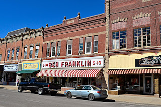
We went into the Ben Franklin Five and Dime and got some Alieve for Jim. They had a little bit of everything. Most of the buildings around the square are circa 1870 and very interesting. There is a lot of brickwork and stone carvings.

Later we went half a mile in the opposite direction to the new Shopko and HyVee to pick up a few things. Across from HyVee, in front of a bank, we saw another hay sculpture -- a puppy with a dollar sign on his chest.

To top off the day, Rob took Jim for a ride in his muscle/race car. As they returned up the road to the house, he burnt rubber and quickly turned into the garage to hide from the neighbors.

We went out to the Pizza Hut for dinner. It was a very nice day and visit with Rob and Linda.
Tomorrow we head out towards Florida.
Sunday, September 22, 2013
Day 6: Chariton, Iowa 192.9 Miles; 3:15
We got up and and took our second meal card over to Penny's Diner. It covered breakfast for both of us plus coffee and tea. I bought a Penny's Diner mug to go with our old Wall Drug mug at home. Thought it would be "useful."
We have noticed significantly more bug spatter since we got to the Missouri river. And I can hear the bug sounds all around (locus are especially active.) It is sort of a background noise that you don't notice if you live here, but coming from the West where we don't hear it, it is noticeable. Brings back memories of growing up in Kansas. I don't miss the chiggers or the locus, but do miss the lightning bugs in July.
The landscape here is similar to where I grew up in Kansas. Short trees, corn fields, rolling hills, silos and farmland. We finally figured out the "Modern Rest Area" signs. It seems that in Iowa, "rest area" is a parking area with no facilities. So it isn't that they have outhouses as Jim surmised -- they just have bushes. "Modern" rest areas, however, have bathrooms. In South Dakota has the same system, but they call the non-facility variety "parking areas" and the facility variety "rest areas."
As we headed towards Des Moines we suddenly encountered white windmills, then more and more of them. Jim said it was a windmill farm, but to me it was more like a windmill forest. It seems to me that windmills are the tall trees of Iowa. Just like the tall trees of the NW, they block out sky and horizon views. They also use windmill blades as abstract sculpture in front of buildings in Iowa, or at least we saw one being used that way at a "modern" rest stop.
We passed a sign for a "Danish Windmill Museum," a "Silo and Smokestack Heritage Area", and a Tractor museum. The Tractor museum has over 150 full-sized tractors plus a toy tractor exhibit and other farm items. They even have a small doll collection in a room named the "Tractor Widow's Lounge." It seems like in the MidWest "points of interest" are more man-made than nature-made
 We arrived at Rob and Linda's house in Chariton around noon. They have made a lot of improvements to the house since we were last here. Rob and a neighbor built a large shop, and Rob has been remodeling the house. Most recently he completely redid the bathroom, which looks great.
At the back of the shop, Rob built a room that he uses to make diesel and soap from discarded cooking oil that he collects downtown. They run one of their trucks with it and don't need to buy gas. They jokingly call it their "meth lab" and I'll have to admit that it does look like something straight our of "Breaking Bad."
Rob and Linda have been doing some landscaping as well. They planted a row of arborvitae along the sidewalk and installed an arbor with a gate and have put in lots of plants around the house.
They bought one plant at Lowe's that came with it's own hummingbird -- following them right out of the store. Or at least they thought it was a small hummingbird until they looked it up and discovered it was actually a moth called the hummingbird moth. And we got to see it. They have lots of hummingbirds too. Amazing how similar they look as they are hovering over a flower. I took some pictures and when you stop the action, you can see that it has moth characteristics.


For several years now Rob has been buying tax liens. Every once and a while he ends up with a house. This happened recently and he and Jim slipped away to see the house. Linda and I followed. They couldn't get rid of us that easy! The house is in disrepair (as you would expect). At one time it was divided into three apartments. There are tons of stuff that the people left behind and it's going to take Rob and Linda some time to go through everything and get it cleaned out before they can start work on it. Problem is it is not all junk. There are some valuable or at least sellable items along the junk.

The house is pre-1900 and has some beautiful wood flooring and other features. Jim thinks it would be a beautiful house if restored. Rob is putting a roof on it and then putting up a "For Sale" sign while he continues to fix it up. Hopefully someone will see the potential and snap it up.

We also went by a building that Rob's partner in tax sales picked up and is letting Rob use for storage. They have their boat there and plan to rent out space for storage of recreational items and such.
Linda and I took off on our own for a tour of "hay round" sculptures around town. Hay rounds are like hay bales only rolled up into large cylindrical bales. Every year in Chariton they have a contest for the best hay sculpture. They will judge and announce the winner around Halloween.

We have noticed significantly more bug spatter since we got to the Missouri river. And I can hear the bug sounds all around (locus are especially active.) It is sort of a background noise that you don't notice if you live here, but coming from the West where we don't hear it, it is noticeable. Brings back memories of growing up in Kansas. I don't miss the chiggers or the locus, but do miss the lightning bugs in July.
The landscape here is similar to where I grew up in Kansas. Short trees, corn fields, rolling hills, silos and farmland. We finally figured out the "Modern Rest Area" signs. It seems that in Iowa, "rest area" is a parking area with no facilities. So it isn't that they have outhouses as Jim surmised -- they just have bushes. "Modern" rest areas, however, have bathrooms. In South Dakota has the same system, but they call the non-facility variety "parking areas" and the facility variety "rest areas."
As we headed towards Des Moines we suddenly encountered white windmills, then more and more of them. Jim said it was a windmill farm, but to me it was more like a windmill forest. It seems to me that windmills are the tall trees of Iowa. Just like the tall trees of the NW, they block out sky and horizon views. They also use windmill blades as abstract sculpture in front of buildings in Iowa, or at least we saw one being used that way at a "modern" rest stop.
We passed a sign for a "Danish Windmill Museum," a "Silo and Smokestack Heritage Area", and a Tractor museum. The Tractor museum has over 150 full-sized tractors plus a toy tractor exhibit and other farm items. They even have a small doll collection in a room named the "Tractor Widow's Lounge." It seems like in the MidWest "points of interest" are more man-made than nature-made
 We arrived at Rob and Linda's house in Chariton around noon. They have made a lot of improvements to the house since we were last here. Rob and a neighbor built a large shop, and Rob has been remodeling the house. Most recently he completely redid the bathroom, which looks great.
At the back of the shop, Rob built a room that he uses to make diesel and soap from discarded cooking oil that he collects downtown. They run one of their trucks with it and don't need to buy gas. They jokingly call it their "meth lab" and I'll have to admit that it does look like something straight our of "Breaking Bad."
Rob and Linda have been doing some landscaping as well. They planted a row of arborvitae along the sidewalk and installed an arbor with a gate and have put in lots of plants around the house.
They bought one plant at Lowe's that came with it's own hummingbird -- following them right out of the store. Or at least they thought it was a small hummingbird until they looked it up and discovered it was actually a moth called the hummingbird moth. And we got to see it. They have lots of hummingbirds too. Amazing how similar they look as they are hovering over a flower. I took some pictures and when you stop the action, you can see that it has moth characteristics.

Rob was smoking some chickens for dinner when we got there. He is quite a chef. He also smokes
jerky, cheese, and every kind of meat. He got two deer this year and he made summer sausage, and even breakfast sausage. Their garden is going strong as well and they do a lot of canning. We enjoyed
a wonderful meal from the garden and smoker.

For several years now Rob has been buying tax liens. Every once and a while he ends up with a house. This happened recently and he and Jim slipped away to see the house. Linda and I followed. They couldn't get rid of us that easy! The house is in disrepair (as you would expect). At one time it was divided into three apartments. There are tons of stuff that the people left behind and it's going to take Rob and Linda some time to go through everything and get it cleaned out before they can start work on it. Problem is it is not all junk. There are some valuable or at least sellable items along the junk.

The house is pre-1900 and has some beautiful wood flooring and other features. Jim thinks it would be a beautiful house if restored. Rob is putting a roof on it and then putting up a "For Sale" sign while he continues to fix it up. Hopefully someone will see the potential and snap it up.

We also went by a building that Rob's partner in tax sales picked up and is letting Rob use for storage. They have their boat there and plan to rent out space for storage of recreational items and such.
Linda and I took off on our own for a tour of "hay round" sculptures around town. Hay rounds are like hay bales only rolled up into large cylindrical bales. Every year in Chariton they have a contest for the best hay sculpture. They will judge and announce the winner around Halloween.

Sculptures around town - Iowa style.
Saturday, September 21, 2013
Day 5: Missouri Valley, Iowa (444.2 miles; 6:08 drive time)
Jim was watching football (it's Saturday) and I noticed the coverage on the North Dakota State team, the Bison. They beat Kansas State and Fargo was going wild for the home game today. I learned some interesting things about Bison (the actual animals.) They can run up to 35 mph, are a herd animal (if one gets out of a fence - they all do) and they can attack for no reason. Makes me feel lucky about our recent encounters. Also, according to one burly football player, "You pronounce it ' by-ZEN.'" I just looked up the results from their game today. The Bison won 51 to 0 over Delaware. I'm sure they are celebrating in the street.
We got up, had breakfast, and decided to take a walk to Wall Drugs. Jim and I have been to Wall Drugs before, many years ago. We even have coffee cups with their logo to prove it. BUT neither of us remembered this store. It, like Mount Rushmore, had made significant changes in 15 years. What we remember is one store with lots of goods right along the highway. Something like Jacks General Store in Ocean Park.

What we found today was halfway between two freeway exits and taking up an entire block. It is sort of a combination of Jake's Free Museum and Stormin' Norman's in Long Beach, Washington. When I told this to Jim, he said, "Jacks is useful." This told me he didn't find Wall Drugs very "useful."
It is, however, very interesting to browse through the complex. It is like a museum of sorts. There are 4 or 5 entrances into separate store areas: books, western wear, western and Indian art, t-shirts and souvenirs, a cafe that can seat 500, a traveler's chapel, and a small section of drug store items (a selection you might find at a convenience store.) The inner hallways are decked out with western, old town mannequins, stuffed game animals, and a variety of antique western artifacts. The street in front has been set up to maximize parking and a row of what looks like newly build western-style shops lines the other side of the street.

We saw a picture of the original store -- quite a change over the years. They are still skilled at marketing to tourists. Looking at the map I discovered that Wall is at the end of a scenic loop through Badlands National Park. That explains why the small town was so busy and the large number of motels to local population ratio for the small town.
We started off on I-90 and immediately ran into road construction, of course. We skipped the turn-off to the Badlands loop -- we have 614 miles to Chariton and wanted to get on our way. We'll save that for another trip.
We were definitely in the Great Plains. The road was perfectly straight, no trees, flat grassland all around and a 360-degree view of the horizon. We passed an attraction beside the road called "1880 Town." It was visible for miles and looked like a replica of an old western town. Shortly afterwards, we saw a life-size model of a dinosaur skeleton that looked like it was going to eat a smaller life-size skeleton of a man. I know that they have found a lot of fossil remains in this area and Mammoth Hot Springs is not too far away. Maybe there was some connection - but no signs of explanation.
We passed a sign informing us we were entering the Central Time Zone and set the clocks up an hour. A few hours into this, Jim said, "I could use a change of scenery." I said, "Welcome to the Great Plains." Just west of Chamberlain we started to see some small hills and ran into the first curve in the road. We were getting near the Missouri River. The receptionist at the motel had suggested to me that we stop at the rest stop in Chamberlain for a view of the river, so we took her advise.

It was very windy, but we had a great view of the river. There was a Lewis and Clark exhibit there as well. From now on it looks like we will be following the Lewis and Clark trail. We saw the familiar Lewis and Clark highway signs that are so common at home.
They evidently have poison snakes here as well as Oregon. We braved the trail but fortunately only ran into grasshoppers.

Back on the road, the landscape flattened out again and we passed a number of cornfields. The corn seemed unusually short though (3 or 4 feet). We passed a sign pointing out the home of Laura Ingle Wilder, author of "Little Home in the Prairie."
As we approached I-29, I discovered we could head north to Fargo (Bison). We decided not to. Instead, we turned south onto I-29 at Sioux Falls (population 153,888; elevation 1400). This was by far the largest city we've been through on this trip. It is named after the Big Sioux River which runs through town.
The Lakota Sioux called the river "Laughing Waters." You understand after traveling through this country how important rivers are. We saw a number of bare-headed riders. Seemed strange coming from an area where everyone on anything with less than 4 wheels wears a helmet.
About 60 miles later as we crossed the Big Sioux River into Iowa, Jim announced, "We are 368 miles from Wall Drugs." We passed a riverboat casino and a sign warning us that speed limits were strictly enforced with SPEED CAMERAS. Thanks, Gary.
Also saw a sign for a "modern rest area." Jim wondered if the non-modern ones had out-houses. Most rest stops in Iowa have Wi-Fi ... maybe that is what they meant?
We started to see some trees -- short ones-- or as Jim says, "Trees cleverly disguised as bushes." I'll have to admit after living in the Northwest for a number of years, midwestern trees do look like bushes. When I first moved to the Northwest after growing up in the midwest, one if the first things I noticed were the "tall" trees. I told my mother that, "they have tall trees here." She thought I was exaggerating and didn't believe me. But when she first came to visit, I saw her looking up at the trees and saying to me, "They do have tall trees here." Tall trees get in the way of viewing the sky or horizon. Short trees don't. You can still see lots of sky and the horizon from all directions in this country.
We stopped for the night at Missouri Valley( population: 2,838; elevation: 1007), just north of Omaha. I found a motel in the AAA guide book named "Oak Tree Inn" and we set the address for Miss Direction. When we arrived we found a 50's style diner, "Penny's Diner," next door and a sign saying to check into the hotel at the diner.

They give you a ticket when you check in for a free breakfast in the diner. (Or you can use it to get $7.75 off any meal there.) The prices are very reasonable. We used one of the coupons for dinner and only had to pay $3.00 for both meals. And we have the other ticket for breakfast!
 The hotel and diner are surrounded by cornfields on 3 sides. This corn is tall and it looks interesting to see cars parked right next to the corn or to see the corn outside the diner windows.
We must be in Iowa.
We got up, had breakfast, and decided to take a walk to Wall Drugs. Jim and I have been to Wall Drugs before, many years ago. We even have coffee cups with their logo to prove it. BUT neither of us remembered this store. It, like Mount Rushmore, had made significant changes in 15 years. What we remember is one store with lots of goods right along the highway. Something like Jacks General Store in Ocean Park.

What we found today was halfway between two freeway exits and taking up an entire block. It is sort of a combination of Jake's Free Museum and Stormin' Norman's in Long Beach, Washington. When I told this to Jim, he said, "Jacks is useful." This told me he didn't find Wall Drugs very "useful."
It is, however, very interesting to browse through the complex. It is like a museum of sorts. There are 4 or 5 entrances into separate store areas: books, western wear, western and Indian art, t-shirts and souvenirs, a cafe that can seat 500, a traveler's chapel, and a small section of drug store items (a selection you might find at a convenience store.) The inner hallways are decked out with western, old town mannequins, stuffed game animals, and a variety of antique western artifacts. The street in front has been set up to maximize parking and a row of what looks like newly build western-style shops lines the other side of the street.

We saw a picture of the original store -- quite a change over the years. They are still skilled at marketing to tourists. Looking at the map I discovered that Wall is at the end of a scenic loop through Badlands National Park. That explains why the small town was so busy and the large number of motels to local population ratio for the small town.
We started off on I-90 and immediately ran into road construction, of course. We skipped the turn-off to the Badlands loop -- we have 614 miles to Chariton and wanted to get on our way. We'll save that for another trip.
We were definitely in the Great Plains. The road was perfectly straight, no trees, flat grassland all around and a 360-degree view of the horizon. We passed an attraction beside the road called "1880 Town." It was visible for miles and looked like a replica of an old western town. Shortly afterwards, we saw a life-size model of a dinosaur skeleton that looked like it was going to eat a smaller life-size skeleton of a man. I know that they have found a lot of fossil remains in this area and Mammoth Hot Springs is not too far away. Maybe there was some connection - but no signs of explanation.
We passed a sign informing us we were entering the Central Time Zone and set the clocks up an hour. A few hours into this, Jim said, "I could use a change of scenery." I said, "Welcome to the Great Plains." Just west of Chamberlain we started to see some small hills and ran into the first curve in the road. We were getting near the Missouri River. The receptionist at the motel had suggested to me that we stop at the rest stop in Chamberlain for a view of the river, so we took her advise.

It was very windy, but we had a great view of the river. There was a Lewis and Clark exhibit there as well. From now on it looks like we will be following the Lewis and Clark trail. We saw the familiar Lewis and Clark highway signs that are so common at home.
They evidently have poison snakes here as well as Oregon. We braved the trail but fortunately only ran into grasshoppers.

Back on the road, the landscape flattened out again and we passed a number of cornfields. The corn seemed unusually short though (3 or 4 feet). We passed a sign pointing out the home of Laura Ingle Wilder, author of "Little Home in the Prairie."
As we approached I-29, I discovered we could head north to Fargo (Bison). We decided not to. Instead, we turned south onto I-29 at Sioux Falls (population 153,888; elevation 1400). This was by far the largest city we've been through on this trip. It is named after the Big Sioux River which runs through town.
The Lakota Sioux called the river "Laughing Waters." You understand after traveling through this country how important rivers are. We saw a number of bare-headed riders. Seemed strange coming from an area where everyone on anything with less than 4 wheels wears a helmet.
About 60 miles later as we crossed the Big Sioux River into Iowa, Jim announced, "We are 368 miles from Wall Drugs." We passed a riverboat casino and a sign warning us that speed limits were strictly enforced with SPEED CAMERAS. Thanks, Gary.
Also saw a sign for a "modern rest area." Jim wondered if the non-modern ones had out-houses. Most rest stops in Iowa have Wi-Fi ... maybe that is what they meant?
We started to see some trees -- short ones-- or as Jim says, "Trees cleverly disguised as bushes." I'll have to admit after living in the Northwest for a number of years, midwestern trees do look like bushes. When I first moved to the Northwest after growing up in the midwest, one if the first things I noticed were the "tall" trees. I told my mother that, "they have tall trees here." She thought I was exaggerating and didn't believe me. But when she first came to visit, I saw her looking up at the trees and saying to me, "They do have tall trees here." Tall trees get in the way of viewing the sky or horizon. Short trees don't. You can still see lots of sky and the horizon from all directions in this country.
We stopped for the night at Missouri Valley( population: 2,838; elevation: 1007), just north of Omaha. I found a motel in the AAA guide book named "Oak Tree Inn" and we set the address for Miss Direction. When we arrived we found a 50's style diner, "Penny's Diner," next door and a sign saying to check into the hotel at the diner.

They give you a ticket when you check in for a free breakfast in the diner. (Or you can use it to get $7.75 off any meal there.) The prices are very reasonable. We used one of the coupons for dinner and only had to pay $3.00 for both meals. And we have the other ticket for breakfast!
 The hotel and diner are surrounded by cornfields on 3 sides. This corn is tall and it looks interesting to see cars parked right next to the corn or to see the corn outside the diner windows.
 We must be in Iowa.
Friday, September 20, 2013
Day 4: Wall, SD 369.6 miles; 6:05 drive time
We got up and took our walk down the street from the motel to the Walmart to pick up a few essentials. This was a much less scenic walk than usual. Sort of like walking down Highway 99 in Hazel Dell. The motel itself was historic; the area around it, not so much.
We got back onto I-90, Jim put the cruise control on his favorite number, 75, and off we went. We were making much better time than yesterday and we were hoping to get to Mount Rushmore around noon -- but that was not to be.
We passed through Buffalo, WY (population 4585; elevation 4645) This was the place where many Native American battles were fought. The Bozeman Trail ran through Indian land in this area which caused problems for both. The town itself was founded in 1879 and became known as "Rustler's Capital." In 1892 the cattlemen and farmers went to war. It was called the Johnson County War and the US Army had to be called in to make peace.
The land has turned to rolling hills of grassland and prairie - not a tree in sight. Jim spotted a herd of pronghorn deer grazing on one of the hills. We also saw our first Wall Drug sign in this area. (More on that later.)
Shortly thereafter our luck ran out. All of a sudden cars were slowing down and turning on their hazard lights. Then we saw road construction signs warning that we should prepare for a delay up to one hour! Then we saw in front of us an oversized vehicle that was taking up the full two lanes (no one could pass). It was going slow and then stopped and everything ground to a stop. At this point we were the third car behind the OV.
 After we stopped, we saw a lot of activity. The highway workers were all gathered around and several trucks with flashing lights arrived. I got out and took some pictures. Jim was somewhat disturbed when he saw that the highway workers were also taking pictures. So there we sat, and sat as the cars backed up behind us for miles.
After about 30 minutes there was some activity and the OV started moving, but the flag person would not let the cars follow.
We sat some more as we watched the OV creep along the 2-lane part of the freeway. They had stopped the cars in the other direction too. Turns out they needed both lanes to the the OV through and they were going along with it moving traffic cones so it could get through. We met a nice fellow named Doug who was traveling with his wife to Virginia Beach for a Navy reunion.
Finally, after an hour and a half (we could have been to Mt. Rushmore) we began to move. Our worst nightmare was that the OV would be on the highway when we got through, an there it was. Fortunately, they had pulled to the side of the road so we could get through. At this point, Jim had to admit there were worse things than being stuck behind a slow RV. How about an OV taking up the whole road?t felt good to be on the way again, but we kept running into construction all day.
Next city was Gillette (population 29K; elevation 4538). Gillette is on a high plateau between the Bighorn Mountains and Black Hills. It is known for livestock, coal, and oil. We passed by a pit coal mine on one side of the freeway and a coal burning power station on the other (tow transportation costs!).
As we got into the hills, we came to Sundance (population 1,182; elevation 4756). Sundance lies at the foot of Sundance Mountain named for the ceremonies that the Sioux held near here. It is believed that Harry Longabaugh, better known as "The Sundance Kid," got his nickname during the 18 months that he spent in the Crook County Jail for horse stealing. What an appropriate name for a jail.....
As we passed the town of Moorcraft, I tested out my tablet's 3G connection to look up the name of Sherlock Holmes's older brother -- which we both thought of when we saw the name of this town. Turns out his name is "Mycroft." Isn't the web wonderful? We stopped at a rest stop near here and ran into Doug again. We saw him again at Mount Rushmore. I wonder if we will cross paths again.
Into South Dakota at last. And the speed limit remains 75! First town we pass is Spearfish (population 10, 494; elevation 3642). This town got its name because the Sioux used to come to the creek that runs through town to spear fish. The creek is unique in that it freezes from the bottom (making the fish come up) and flows from south to north
Next town was Sturgis (population 6627; elevation 3468). This was the home of the infamous cigar-smoking card shark named "Poker Alice." She owned the rowdiest honky tonk in the State. Jim commented that this is also the gathering point for hundreds of thousands of motorcyclists each year where they hold a rally. So I'm guessing Alice's legacy is continuing.
We are getting closer to the presidents. We turned off in Rapid City and headed to the monument. Rapid City has a population of 67,956 and elevation of 3220 feet. This was the area where they filmed "Dances with Wolves" and is home of the "City of Presidents" Project. The goal of this project is to place a life-size bronze statue of each president on the city streets, standing as if a pedestrian. So far they have 43 presidential pedestrians in place.
Keystone (population 337; elevation 4341) is only 2 miles from Mount Rushmore. It is definitely a tourist town today but started as a mining town. One of the largest mine owners named one of his mines the "Holy Terror Gold Mine" after his wife. She took the joke well when the mine started producing $70,000 worth of gold PER WEEK!
 Finally we arrived at Mount Rushmore. We had our golden pass ready, but they charged a "parking fee" of $11 and did not take passes. The place had also been enlarged significantly since we were last here about 15 years ago. At that time there was just a wooden building that served as information center and viewing room. They now have an amphitheater and outdoor viewing area in addition a large cafe, ice cream shop, and gift shop. It has gone commercial in a big way. I suppose with federal funds dwindling, the parks have to make money any way they can -- but the contrast was striking. They had an ice cream shop that had a sign with a picture of Jefferson claiming that he signed the Declaration of Independence and invented the first recipe for ice cream. And of course you could buy some of his ice cream there. I also enjoyed the "Made in USA" area of the gift shop. There were lots of languages spoken there, and I suppose it is frustrating to buy an American souvenir that turns out to be make in your own country.
Unlike our last visit in the fog, this time the Presidents were out in all their splendor. Very awesome.

Jim told me about a mountain carving of an Indian Chief that was in the area. He asked at the information center and found out it was the Crazy Horse Monument. We tapped that into Miss Direction and off we went. When we got to the gate the admission was $10 each, which I thought was high. That is, until we got there. They first direct you to a video explaining the project and the amazing story of this mountain carving. It was started in 1949 and is still going on. A sculptor named Korczak was invited by Lakota Chief Henry Standing Bear to carve a statue of Crazy Horse. The chief was speaking for a group of chiefs and said, "My fellow chiefs and I would like the white man to know the red man has great heros too.
When Korczak started work on the mountain he was almost 40 and had only $174 left to his name.
He was a strong believer in the free enterprise system and felt Crazy Horse should be built by the interested public and not the taxpayer. He turned down offers of federal funding. He married and had 10 children. He died in 1982, but his wife and 7 of his children are continuing the work. The head of Crazy Horse was finished in 1998. They are now working on the horse head. When finished the monument will be 563 feet high and 641 feet wide. The completed face is 9-stories high. The inscription for the work is a quote from Chief Crazy Horse: "My lands are where my dead lay buried."


We got back onto I-90, Jim put the cruise control on his favorite number, 75, and off we went. We were making much better time than yesterday and we were hoping to get to Mount Rushmore around noon -- but that was not to be.
We passed through Buffalo, WY (population 4585; elevation 4645) This was the place where many Native American battles were fought. The Bozeman Trail ran through Indian land in this area which caused problems for both. The town itself was founded in 1879 and became known as "Rustler's Capital." In 1892 the cattlemen and farmers went to war. It was called the Johnson County War and the US Army had to be called in to make peace.
The land has turned to rolling hills of grassland and prairie - not a tree in sight. Jim spotted a herd of pronghorn deer grazing on one of the hills. We also saw our first Wall Drug sign in this area. (More on that later.)
Shortly thereafter our luck ran out. All of a sudden cars were slowing down and turning on their hazard lights. Then we saw road construction signs warning that we should prepare for a delay up to one hour! Then we saw in front of us an oversized vehicle that was taking up the full two lanes (no one could pass). It was going slow and then stopped and everything ground to a stop. At this point we were the third car behind the OV.

After about 30 minutes there was some activity and the OV started moving, but the flag person would not let the cars follow.
We sat some more as we watched the OV creep along the 2-lane part of the freeway. They had stopped the cars in the other direction too. Turns out they needed both lanes to the the OV through and they were going along with it moving traffic cones so it could get through. We met a nice fellow named Doug who was traveling with his wife to Virginia Beach for a Navy reunion.
Next city was Gillette (population 29K; elevation 4538). Gillette is on a high plateau between the Bighorn Mountains and Black Hills. It is known for livestock, coal, and oil. We passed by a pit coal mine on one side of the freeway and a coal burning power station on the other (tow transportation costs!).
As we got into the hills, we came to Sundance (population 1,182; elevation 4756). Sundance lies at the foot of Sundance Mountain named for the ceremonies that the Sioux held near here. It is believed that Harry Longabaugh, better known as "The Sundance Kid," got his nickname during the 18 months that he spent in the Crook County Jail for horse stealing. What an appropriate name for a jail.....
As we passed the town of Moorcraft, I tested out my tablet's 3G connection to look up the name of Sherlock Holmes's older brother -- which we both thought of when we saw the name of this town. Turns out his name is "Mycroft." Isn't the web wonderful? We stopped at a rest stop near here and ran into Doug again. We saw him again at Mount Rushmore. I wonder if we will cross paths again.
Into South Dakota at last. And the speed limit remains 75! First town we pass is Spearfish (population 10, 494; elevation 3642). This town got its name because the Sioux used to come to the creek that runs through town to spear fish. The creek is unique in that it freezes from the bottom (making the fish come up) and flows from south to north
Next town was Sturgis (population 6627; elevation 3468). This was the home of the infamous cigar-smoking card shark named "Poker Alice." She owned the rowdiest honky tonk in the State. Jim commented that this is also the gathering point for hundreds of thousands of motorcyclists each year where they hold a rally. So I'm guessing Alice's legacy is continuing.
We are getting closer to the presidents. We turned off in Rapid City and headed to the monument. Rapid City has a population of 67,956 and elevation of 3220 feet. This was the area where they filmed "Dances with Wolves" and is home of the "City of Presidents" Project. The goal of this project is to place a life-size bronze statue of each president on the city streets, standing as if a pedestrian. So far they have 43 presidential pedestrians in place.
Keystone (population 337; elevation 4341) is only 2 miles from Mount Rushmore. It is definitely a tourist town today but started as a mining town. One of the largest mine owners named one of his mines the "Holy Terror Gold Mine" after his wife. She took the joke well when the mine started producing $70,000 worth of gold PER WEEK!

Unlike our last visit in the fog, this time the Presidents were out in all their splendor. Very awesome.

Jim told me about a mountain carving of an Indian Chief that was in the area. He asked at the information center and found out it was the Crazy Horse Monument. We tapped that into Miss Direction and off we went. When we got to the gate the admission was $10 each, which I thought was high. That is, until we got there. They first direct you to a video explaining the project and the amazing story of this mountain carving. It was started in 1949 and is still going on. A sculptor named Korczak was invited by Lakota Chief Henry Standing Bear to carve a statue of Crazy Horse. The chief was speaking for a group of chiefs and said, "My fellow chiefs and I would like the white man to know the red man has great heros too.
When Korczak started work on the mountain he was almost 40 and had only $174 left to his name.
He was a strong believer in the free enterprise system and felt Crazy Horse should be built by the interested public and not the taxpayer. He turned down offers of federal funding. He married and had 10 children. He died in 1982, but his wife and 7 of his children are continuing the work. The head of Crazy Horse was finished in 1998. They are now working on the horse head. When finished the monument will be 563 feet high and 641 feet wide. The completed face is 9-stories high. The inscription for the work is a quote from Chief Crazy Horse: "My lands are where my dead lay buried."

The center also has the most extensive collection of Native American crafts and artifacts that I have seen. This is definitely something I would like to visit again. It is all financed through a foundation and with admissions and earnings from the gift shop.
Back on the road again, Miss Direction got us back to I-90. On the way we noticed that there are quite a few wineries in the area. They all have very odd names though. For example, we saw signs for "Red Ass Rhubarb Wine", "The Naked Winery", and Jim claims to have seen wine sign for "Buck Naked and Tickle Me."
We finally got to I-90 passing through yet another road construction zone and headed to Wall, home of the famous Wall Drug Store. In 1936 the owners of this small-town pharmacy, Ted and Dorothy Hustead came up with an ingenious marketing campaign. Realizing travelers going through this hot dusty area would be thirsty, they put us signs along the freeway offering free ice water. Folks have been stopping there ever since. Having had success with small signs, they invested in billboards and put them up all over the country. The 1965 Highway Beautification Act forced removal of most of the signs, but they are still up in South Dakota and many countries overseas.

More about Wall Drugs Tomorrow.
Thursday, September 19, 2013
Day 3: Sheriden, WY: 331.5 miles; 6:45 drive time
We had a big decision this morning: whether to go to Yellowstone or not. We have a history with Yellowstone. On one of our trips back from Kansas, I insisted we go through Yellowstone (because we were so close). Only problem was we ended up going through the park on the 4th of July--very bad idea. Traffic was slow, bumper to bumper, and Jim was very unhappy. I had to beg to stop at Old Faithful. On the road north, one of the cars in front of us suddenly stopped in the middle of the road, blocking traffic in both lanes and jumped out to take a photo of an elk that Jim thought was definitely anorexic. Jim has never let me forget this trip. So... Well here we were again - so close. And it wasn't the 4th of July, so I thought I could redeem myself. Jim unenthused finally said OK. So at 8:30 we headed south on highway 89 to Yellowstone, North Entrance.
Things started out fine. There was hardly any traffic and the road was good. When we got to Gardiner, however, we ended up in a caravan including several large RV's heading towards the entrance. At the entrance we chose a separate line from the RV's, but happened to be behind a traveler who got out of his car and wanted to talk to the ranger. An RV slipped in front of us and Jim began to grumble. Fortunately the RV soon turned off at the RV campground.
We stopped at Mammoth Hot Springs to take a walk. They had a lot of boardwalk paths. You couldn't walk on the ground because of the scalding water close to the surface. Signs warning you to stay on the paths mentioned the number of people who were scalded to death. It was effective.

We walked for about an hour and Jim made it to the top. Very impressive. Steamy water everywhere. The park itself reminded me of the Pacific Northwest, only difference was that wherever there was water, there was steam somewhere - even around the large Yellowstone Lake. Jim had seen a documentary that said that essentially the whole park is really the caldron of an ancient gigantic volcano and if it ever erupted again it could take out the entire West. Somewhat mind blowing to think that we were driving around inside a volcano.
We decided to forgo Old Faithful this time and take a short cut to the East exit hoping to avoid some traffic. So we turned left onto Norris Road and immediately began to climb. The roadmap did not indicate that we would be going over a pass, but we noticed a sign that warned of an 8% grade. And up we went. We ended up at 8291 feet (according to Miss Direction) and snow coated trees. It was very pretty - and practically no traffic.
 On the other side of the pass, we joined the circle road and headed south. Then we sited our first wild life, a bison grazing on the golden grass. Jim couldn't stop (memories of the anorexic elk), so no pictures. Then around the bend (where there was a place to park) we saw another one. So I quickly jumped out with my camera to join a small group of folks taking pictures.
We later passed several groups of people stopped, pointing, and taking pictures. I told Jim we should stop at an empty spot and just point our cameras in some direction and see how many people would stop too. We also ran across another area of pointing that had several park rangers involved. I caught a glimpse of a black bear in the distance.
We passed several fields that had a number of bison grazing in the distance. We ended up at Fishing Bridge and Yellowstone Lake. It is a beautiful and large lake with steam rising up from the beach.
 We headed toward the East exit and found ourselves in a narrow winding road in an area that had obviously been devoured by a recent forest fire. Snow was clinging to the burned out tree trunks and it was very picturesque. There was a lot of evidence of previous fires, most was recovering nicely.
As we were traveling down the windy road, Jim said, "Look!" Lumbering down the other side of the road, going in our direction was a huge buffalo. Jim slowed the car and rode for a while along side the animal as I grabbed my camera.
As Jim drove away, we spotted a car coming the other way (on the same side of the road as the bison). The woman had her camera positioned on top of the steering wheel as she drove toward the animal. When we got to the entrance, Jim mentioned to a ranger that there was a bison on the road, but he didn't seem interested. Must be common here.
 We headed east out of the park on Highway 14 to Cody. Cody has a population of 9520, and elevation of 5095 ft. It was founded in 1896 by Co. William "Buffalo Bill" Cody. The highway we were on (14/16/20) is called the Buffalo Bill Cody Scenic Byway. It is billed as the most scenic 52 miles in America. It was pretty, but I don't think the person who coined that had ever been to Arizona or Utah. The landscape was similar, but without the color. Sort of the black and white version.
There were numerous signs telling us to "Watch for Falling Rock." Jim wondered why it wasn't "rocks." He thought it sounded like there was just one rock in all of Wyoming that would fall on you. We did see multiple rocks along the road that had obviously fallen. Cody has a "dug-up-gun" museum (old civil war guns), a famous rodeo, and a bustling downtown that is very western and very metro we thought for a town this remote.
After Cody the country flattens out and as Jim said, "Looks like the Wyoming that we remember." That is, south Wyoming -- we have never traveled north Wyoming before. Shortly after leaving Cody, we passed an Amish horse and buggy along the road.
In about 50 miles we were in Greybull (population 1847; elevation 3788) Greybull is named after an Indian legend about a great albino bison that inhabited the area. After Greybull we headed up scenic highway 14 which would take us over the Big Horn Mountains. We could see the mountains rising up on the horizon. The road is nice, but slow as there are many switch backs as the road goes up to over 9000 feet to get over the mountains. The scenery is fantastic. It reminded me of Zion National Park in Utah.

We made good time until the last 15 miles when we found ourselves behind a horse trailer that wouldn't pull over -- but he eventually turned off. So all in all it was a great drive.
We stopped in Sheriden (with an "s") (population 17,404; elevation 3724) for the night. Sheriden is half way between Yellowstone and Mount Rushmore. In 1866 the area was an unreserved National Native American Territory. A number of tribes occupied the area and fought to keep the white man out of their hunting lands. This culminated in the battle at the Little Big Horn which was fought just outside the current city. After the wars ended, Sheriden was incorporated and became a prominent cattle ranching, farming, and coal mining area.
We are staying in a hotel that was originally an old mill. Got the last downstairs room. I asked for a good place to eat and was directed to an establishment on Main Street. As we headed that way, we noticed a sign that said Main Street was closed due to the Third Thursday Event. So we parked and took our walk down Main Street. It was quite the affair, with a band and a number of booths in the middle of the road. Looked like all of Sheriden were there. One thing of note about downtown is the number of bronze statues they have on display. They have a number that were donated and some that are on loan and "for sale" (none under $10,000). A very nice town. We couldn't find the restaurant, so asked Miss Direction to find one for us. Ended up at a grill inside the Best Western Hotel. Jim has had bad experiences with restaurants in hotels, but to our delight, the food was really good.
We are back at the hotel, but Jim is having bandwidth problems with the DishAnywhere. So he will have to wait to see his football till tomorrow.
Tomorrow we will head for Mount Rushmore and hope the presidents are out of the fog this time. Then on towards Iowa.
Things started out fine. There was hardly any traffic and the road was good. When we got to Gardiner, however, we ended up in a caravan including several large RV's heading towards the entrance. At the entrance we chose a separate line from the RV's, but happened to be behind a traveler who got out of his car and wanted to talk to the ranger. An RV slipped in front of us and Jim began to grumble. Fortunately the RV soon turned off at the RV campground.
We stopped at Mammoth Hot Springs to take a walk. They had a lot of boardwalk paths. You couldn't walk on the ground because of the scalding water close to the surface. Signs warning you to stay on the paths mentioned the number of people who were scalded to death. It was effective.

We decided to forgo Old Faithful this time and take a short cut to the East exit hoping to avoid some traffic. So we turned left onto Norris Road and immediately began to climb. The roadmap did not indicate that we would be going over a pass, but we noticed a sign that warned of an 8% grade. And up we went. We ended up at 8291 feet (according to Miss Direction) and snow coated trees. It was very pretty - and practically no traffic.
 On the other side of the pass, we joined the circle road and headed south. Then we sited our first wild life, a bison grazing on the golden grass. Jim couldn't stop (memories of the anorexic elk), so no pictures. Then around the bend (where there was a place to park) we saw another one. So I quickly jumped out with my camera to join a small group of folks taking pictures.
We later passed several groups of people stopped, pointing, and taking pictures. I told Jim we should stop at an empty spot and just point our cameras in some direction and see how many people would stop too. We also ran across another area of pointing that had several park rangers involved. I caught a glimpse of a black bear in the distance.
We passed several fields that had a number of bison grazing in the distance. We ended up at Fishing Bridge and Yellowstone Lake. It is a beautiful and large lake with steam rising up from the beach.
 We headed toward the East exit and found ourselves in a narrow winding road in an area that had obviously been devoured by a recent forest fire. Snow was clinging to the burned out tree trunks and it was very picturesque. There was a lot of evidence of previous fires, most was recovering nicely.
As we were traveling down the windy road, Jim said, "Look!" Lumbering down the other side of the road, going in our direction was a huge buffalo. Jim slowed the car and rode for a while along side the animal as I grabbed my camera.
As Jim drove away, we spotted a car coming the other way (on the same side of the road as the bison). The woman had her camera positioned on top of the steering wheel as she drove toward the animal. When we got to the entrance, Jim mentioned to a ranger that there was a bison on the road, but he didn't seem interested. Must be common here.

There were numerous signs telling us to "Watch for Falling Rock." Jim wondered why it wasn't "rocks." He thought it sounded like there was just one rock in all of Wyoming that would fall on you. We did see multiple rocks along the road that had obviously fallen. Cody has a "dug-up-gun" museum (old civil war guns), a famous rodeo, and a bustling downtown that is very western and very metro we thought for a town this remote.
After Cody the country flattens out and as Jim said, "Looks like the Wyoming that we remember." That is, south Wyoming -- we have never traveled north Wyoming before. Shortly after leaving Cody, we passed an Amish horse and buggy along the road.
In about 50 miles we were in Greybull (population 1847; elevation 3788) Greybull is named after an Indian legend about a great albino bison that inhabited the area. After Greybull we headed up scenic highway 14 which would take us over the Big Horn Mountains. We could see the mountains rising up on the horizon. The road is nice, but slow as there are many switch backs as the road goes up to over 9000 feet to get over the mountains. The scenery is fantastic. It reminded me of Zion National Park in Utah.

We made good time until the last 15 miles when we found ourselves behind a horse trailer that wouldn't pull over -- but he eventually turned off. So all in all it was a great drive.
We stopped in Sheriden (with an "s") (population 17,404; elevation 3724) for the night. Sheriden is half way between Yellowstone and Mount Rushmore. In 1866 the area was an unreserved National Native American Territory. A number of tribes occupied the area and fought to keep the white man out of their hunting lands. This culminated in the battle at the Little Big Horn which was fought just outside the current city. After the wars ended, Sheriden was incorporated and became a prominent cattle ranching, farming, and coal mining area.
We are staying in a hotel that was originally an old mill. Got the last downstairs room. I asked for a good place to eat and was directed to an establishment on Main Street. As we headed that way, we noticed a sign that said Main Street was closed due to the Third Thursday Event. So we parked and took our walk down Main Street. It was quite the affair, with a band and a number of booths in the middle of the road. Looked like all of Sheriden were there. One thing of note about downtown is the number of bronze statues they have on display. They have a number that were donated and some that are on loan and "for sale" (none under $10,000). A very nice town. We couldn't find the restaurant, so asked Miss Direction to find one for us. Ended up at a grill inside the Best Western Hotel. Jim has had bad experiences with restaurants in hotels, but to our delight, the food was really good.
We are back at the hotel, but Jim is having bandwidth problems with the DishAnywhere. So he will have to wait to see his football till tomorrow.
Tomorrow we will head for Mount Rushmore and hope the presidents are out of the fog this time. Then on towards Iowa.
Wednesday, September 18, 2013
Day 2: Livingston, Montana. 393.8 miles today; 6 hours 15 minutes driving.
We got up about 7am, had our continental breakfast at the motel, and decided to take a walk before departing. Walked back through town to the lake. We stopped at a distinctive moose statue along the sidewalk. He seemed to have a growth on his ear, turned out it was a mouse. We found another moose statue at the swimming area of the lake and he had a mouse as well--on his nose. We looked closer and found that the moose is named Mudgy and the mouse is named Minnie. There are 5 Mudgy/Minnie statues around town forming what we call the "Moose Trail."

The park at the base of the lake is beautiful. We passed other morning walker/joggers. They all seemed to be walking/jogging with a cell phone to their ears. I put my ipod up to my ear so I would fit in... I wanted a picture of Mudgy, but hadn't brought my camera (still raining -- light mist) Then I thought, "I have other devices that take pictures with me, namely my phone and ipod. It is a new phone that I'm still getting used to, so I thought this would give us a good chance to get to know each other. Well, for some reason, when you press the button on the side to take a photo, it takes 9 photos in rapid action. I couldn't get it to take just one! So I thought that I had about 50 moose shots and switched to my ipod. Turns out , I had exactly 0 pictures of Mudgy on my phone. After investigation, I discovered that after taking 9 photos, you have to choose which ones you want to keep and physically save them....The logic escapes me, but I'm glad I took some pics of Mudgy with my ipod. (Although, getting those pictures from the ipod to my mac was another frustrating experience in technology. Jim saved me by looking it up on google.)

Discovered a paddle board store and found out that they have paddle board races in Coeur d Alene. Note to Teresa and Conrad.
We headed out and looked at the temperature: 53 degrees. That is the coldest we've experienced in about 3 months since we had an unusually warm summer with respect to LOW temperatures. As we got back onto I-90, Jim noticed that the speed limit was 75! He was so happy he made me take a picture of the sign. Jim insists that the Nissan just naturally WANTS to go about 75mph. And he let her have "her way" until he got a ticket in Oregon. Funny, I told him, she doesn't want to go that fast when I'm driving. Anyway, he is very happy about the speed limits in Idaho and Montana.
 We passed the old mining town of Wallace (population 784, elevation 3223 ft.)
Wallace is at the junction of four canyons and has several of the world's largest and deepest silver mines. The mines were founded in the late 1800's and have over 200 miles of tunnels. The freeway is elevated going right through the town where you can see many historic buildings with turrets.
Just past a sign that said, "Click it, don't risk it," we entered Montana. They have a lot of traffic slogan signs in Montana. We passed through Missoula. Lewis and Clark were here and the Clark Fork River is Clark's namesake. The city is located in a valley that once formed the great Glacial Lake Missoula which was responsible for the rush of water that helped create the Columbia River Gorge. No lake these days, just river and rolling hills. This is elk and lumber country.
 Just after Missoula, Jim abruptly pulled to the side of the freeway and told me to take a picture of a sign. This was a sign that he had seen on our last trip and I didn't believe him. This time he wanted some evidence.
The landscape has changed since we went over the pass into Montana. It more like the Bend area, high desert. Even so, the rain is still following us, on and off.
When we approached Deer Lodge, Jim said, "Let's get off here. I want to show you a place that my uncle took me." Jim's uncle was the sheriff of Cascade County in Montana and Deer Lodge was home of the Montana State Prison until 1979. When Jim was a young lad, visiting his aunt and uncle, his uncle took a prisoner named "Indian Joe" to the prison and Jim came along. He had to wait in the car, but remembered the trip and the prison. Evidently Joe wanted to get back into the prison and asked Jim's uncle if he would just take him back. Sheriff John said no, can't do that. So Joe threw a rock through some windows or something to earn his trip back to what he considered "home."
 We found the prison which is now a museum. In fact, it is now a prison museum AND classic car museum combined (to the right, the prison; to the left, the cars). So that was a pleasant surprise for Jim. After looking at the prison, I con't imagine why Joe wanted to go back there. They had a small building on the side with about 10 cells that they turned into the women's prison. They started by putting their first woman prisoner in the same area as the men, but quickly realized that wasn't working and had the separate building by the time the second woman felon was admitted. The men's cells had a toilet in them, the women's did not. We couldn't quite figure that out. In an old theatre building (looked like a barn) they had the "galloping gallows" on display. Evidently they could move the gallows to any location on the grounds as needed. There were some owls and other birds in the building making ghost-like moans -- at least I think it was the birds. Spooky.
On to the car museum. Jim said that they must not like Chevy's because the first 3 or 4 rooms of old cars were mainly Fords. But then we got to the "Chevy Room" with cars Jim drooled over. And the final room was the best yet, the Corvette room. Jim posed for me by his favorite. He entered a raffle to win a 1960's vintage powder blue Mustang 290 4-speed convertible. He is sure he is going to win and thus solve his current dilemma about replacing the Buick.


Discovered a paddle board store and found out that they have paddle board races in Coeur d Alene. Note to Teresa and Conrad.
We headed out and looked at the temperature: 53 degrees. That is the coldest we've experienced in about 3 months since we had an unusually warm summer with respect to LOW temperatures. As we got back onto I-90, Jim noticed that the speed limit was 75! He was so happy he made me take a picture of the sign. Jim insists that the Nissan just naturally WANTS to go about 75mph. And he let her have "her way" until he got a ticket in Oregon. Funny, I told him, she doesn't want to go that fast when I'm driving. Anyway, he is very happy about the speed limits in Idaho and Montana.

Wallace is at the junction of four canyons and has several of the world's largest and deepest silver mines. The mines were founded in the late 1800's and have over 200 miles of tunnels. The freeway is elevated going right through the town where you can see many historic buildings with turrets.
Just past a sign that said, "Click it, don't risk it," we entered Montana. They have a lot of traffic slogan signs in Montana. We passed through Missoula. Lewis and Clark were here and the Clark Fork River is Clark's namesake. The city is located in a valley that once formed the great Glacial Lake Missoula which was responsible for the rush of water that helped create the Columbia River Gorge. No lake these days, just river and rolling hills. This is elk and lumber country.
 Just after Missoula, Jim abruptly pulled to the side of the freeway and told me to take a picture of a sign. This was a sign that he had seen on our last trip and I didn't believe him. This time he wanted some evidence.
The landscape has changed since we went over the pass into Montana. It more like the Bend area, high desert. Even so, the rain is still following us, on and off.
When we approached Deer Lodge, Jim said, "Let's get off here. I want to show you a place that my uncle took me." Jim's uncle was the sheriff of Cascade County in Montana and Deer Lodge was home of the Montana State Prison until 1979. When Jim was a young lad, visiting his aunt and uncle, his uncle took a prisoner named "Indian Joe" to the prison and Jim came along. He had to wait in the car, but remembered the trip and the prison. Evidently Joe wanted to get back into the prison and asked Jim's uncle if he would just take him back. Sheriff John said no, can't do that. So Joe threw a rock through some windows or something to earn his trip back to what he considered "home."
 We found the prison which is now a museum. In fact, it is now a prison museum AND classic car museum combined (to the right, the prison; to the left, the cars). So that was a pleasant surprise for Jim. After looking at the prison, I con't imagine why Joe wanted to go back there. They had a small building on the side with about 10 cells that they turned into the women's prison. They started by putting their first woman prisoner in the same area as the men, but quickly realized that wasn't working and had the separate building by the time the second woman felon was admitted. The men's cells had a toilet in them, the women's did not. We couldn't quite figure that out. In an old theatre building (looked like a barn) they had the "galloping gallows" on display. Evidently they could move the gallows to any location on the grounds as needed. There were some owls and other birds in the building making ghost-like moans -- at least I think it was the birds. Spooky.
On to the car museum. Jim said that they must not like Chevy's because the first 3 or 4 rooms of old cars were mainly Fords. But then we got to the "Chevy Room" with cars Jim drooled over. And the final room was the best yet, the Corvette room. Jim posed for me by his favorite. He entered a raffle to win a 1960's vintage powder blue Mustang 290 4-speed convertible. He is sure he is going to win and thus solve his current dilemma about replacing the Buick.

Back on the road again, we went through copper country passing by Anaconda, and Butte. Just after Butte, we went over the Continental Divide at an elevation of 6393 feet passing through rain squalls. This was different from the Washington-like rain (drizzle) of the day before. These squalls were spotty, but very intense. And the mountains are getting taller with snow caps now as we approach Yellowstone territory.
We stopped in Livingston (population 7K, elevation 4500) for the night. There was a group of standard motels, but one stood out. The Livingston Inn Motel has a very western and touristy look -- so different from the regular motel chains. Jim said he felt like singing "Home on the Range" as he entered the room. Lots of wood panelling to give it a faux log-cabin feel... And we got an actual key (not a key card). We got a real key last night as well.
We read about the Montana Rib and Chop House in our AAA guide book (paper). When we got there the parking lot was packed which was good and possibly bad news. The food is probably good, but since we didn't have a reservation (which was recommended), could we get in? Luckily they had a table right at the front and slipped us in.
Jim ordered the baby back ribs (which according to the waitress won an award in New Orleans) and I had a shrimp salad which was delicious as well. I asked if they had any local beers. My choices were Moose Drool (from Missoula) and Red Lodge Bent Nail IPA (from Red Lodge). "Dorothy you are not in the Northwest anymore..." I chose the Bent Nail (reminded me a little of Rusty Grape). Told Jim I couldn't quite get past the image that Moose Drool conjured up. He said, "It could have been worse. It's from Missoula, so it could have been Moose Testicle something." Only in Montana...
Tuesday, September 17, 2013
Day 1: Coeur d Alene, Idaho 392.5 miles, 6:10 hour drive.
We departed Battle Ground at 10:34. At 10:35, we took our first wrong turn. Turned around at Lucky Spoke Ranch, and got back on track headed for I-205. We are going east, so knew we wanted to get onto I-84, but really hadn't planned after that. At 10:38, we decided to look at a map.
We had time to make a decision since the road doesn't fork until just after Boardman. We debated our options (go north, go south) and decided to go north, then catch I-90 east and go across Montana. We will dip down in Wyoming catching the site of Custer's last stand, then head east through South Dakota. We are hoping to see Mt Rushmore. We travelled this route many years ago, but the Presidents were hidden in the fog (Presidents in the mist). Maybe we can catch them this time.
The Gorge was beautiful as always. The river had lots of surf, but not a wind surfer in sight. We stopped at the rest stop just before The Dalles. Went for a walk to stretch my legs and noticed lots of picnic tables, no people. Then I saw the signs.

I braved the path and was rewarded by a great view through the truck parking lot.

After The Dalles, we entered goat country. This is dry country with wheat-colored grass, sparse patches of green bushes or trees with black rocks peaking through. The black rocks become black cliffs. We've travelled this road many times, but I've yet to spot a goat. Most of the rest of the family have spotted them. No luck this time
After milepost 105, we were in windmill country. Huge ones on every hill. We turned north and headed past Umatilla to the Tri-Cities. This country seems very Kansasesque. No trees, golden grass. You can see the horizon in all directions.
Miss Direction earned her keep getting through Kennewick and Pasco. Lots of turns and exits. We have her this trip instead of a trip-tik and she is working well. She doesn't like directing you without an address, so I've gotten good at making up addresses in cities in the direction we want to go. Just have to remember to keep changing them.
Kennewick means "winter paradise" in Yakama tongue. Irrigation transformed the desert into farmland. The annual rainfall here is under 8 inches. And it was raining (what are the chances?)
Pasco is the oldest of the Tri-Cities. It started out as a railroad camp and is still a big rail center with the BNSF railway yards. Elevation here is about 380 feet and population is about 60K. A construction engineer named the settlement Pasco after a Peruvian mining town named Cerro do Pasco. There's a trivia question for you.
We passed the turnoff for the Hanford Reach National Monument. This is a reserve of 195,000 acres set aside in 2000 protecting the last wild running stretch of the Columbia River. It would have been about 70 miles to the overlook. The last 8.5 miles are via a gravel road. This gets you to a panoramic view "encompassing the bluffs, the river, and a series of former plutonium production reactors on the Hanford site." Sounds like the good, the bad and the radioactive. Somehow, I couldn't convince Jim to take the turn-off.
He did take the turn off for the next rest stop. That is until he saw that we had to follow the sign that said "to Pullman." He was torn between the call of nature, and the call of a Wazoo alum and avid football fan.....nature won.
This is the warmest driest part of the state, and it's still raining. Still raining through Spokane. We wondered when we would reach Idaho, until we saw a sign that said "Leaving the apple maggot quarantine area." Sure enough the "Welcome to Idaho" sign was right around the corner.
We decided to stop in Coeur d Alene and try to stay at the same motel as on our first trip in 2008. We put the address into Miss Direction and off we went. The motel is called the Flamingo Hotel and it is just at the end of the main downtown street within walking distance of all the shops, restaurants, and lake. When we got there the "NO VACANCY" sign was on. Jim had me call -- just to make sure, but they were full. They said the only other motel in the area was across the street...so we turned around and found the Resort City Inn. They had a room on the ground floor -- perfect!

We really like this town. It has grown in the 5 years since we were here before. I don't remember all the outside seating in the many restaurants and drinking establishments (and it was STILL RAINING). We walked down to the lake and the fancy resort and harbor. They have a floating pier that you can walk on and feel like you are out on the lake. We saw a sea plane back up then go forward and jump up onto the pier next to what looked like a sea plane gas station. Sea planes must be very agile.
We stopped into an establishment called Scratch Restaurant. Sat in the corner window where we could watch people dodging the rain and a variety of cars (It's about time to replace the Buick, so Jim was casing the cars). We had salads and I had a local beer. The food was great. Highly recommend.
When we were here before they were building a new high-rise complex. Well it was finished and we also noticed that the block behind, which I remember as being park-like before, is now under construction -- more high-rises I expect. It's obvious this is a fast-growing area -- just hope it can keep its character in the process.

On to Montana tomorrow......
Subscribe to:
Posts (Atom)